
Macizo de Anaga
Dificultad : Moderado
Distancia : 11 kilómetros -- solo ida --bien señalizado --5 horas
Inicio : En Cruz del Carmen a la derecha del Restaurante del mismo nombre
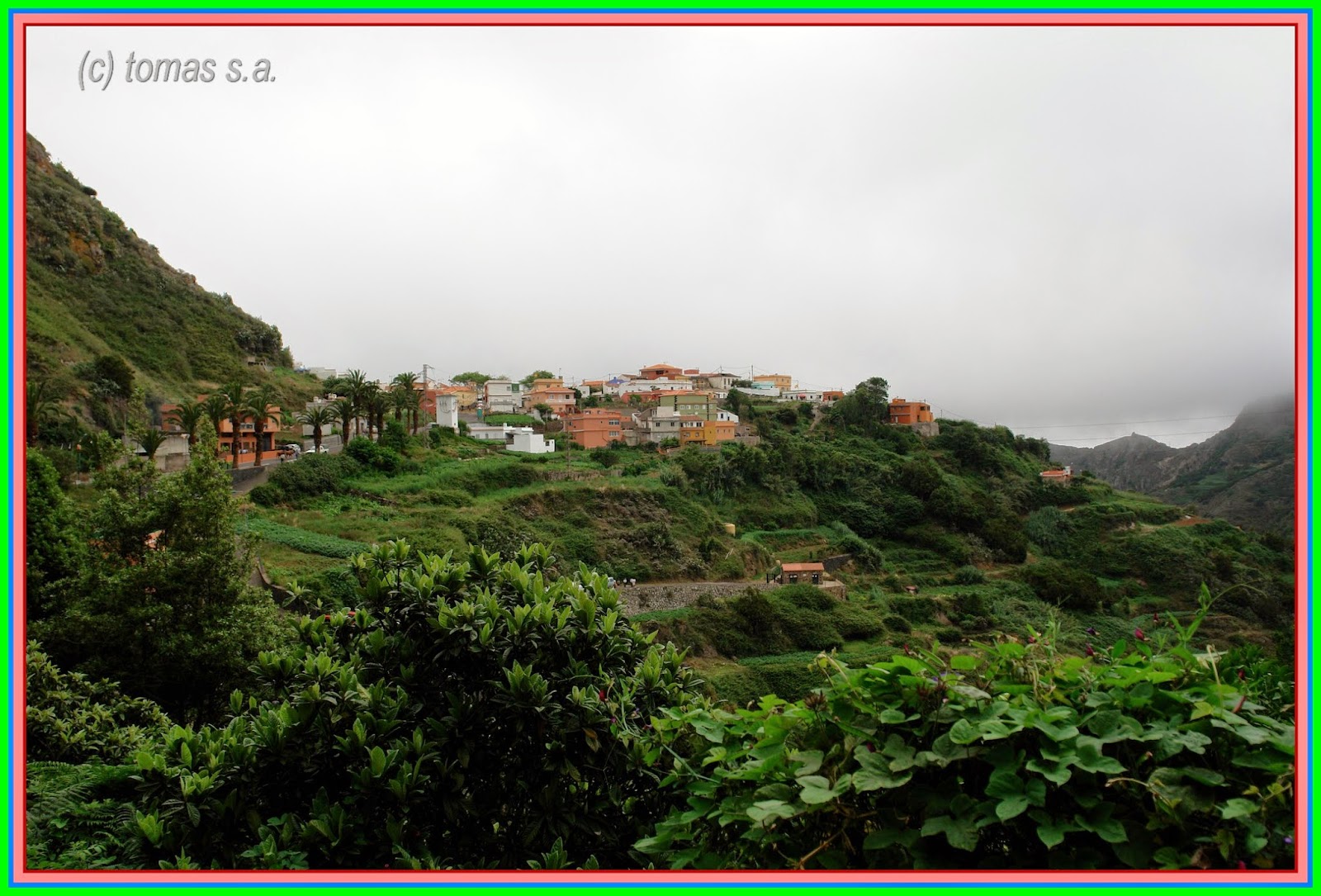
Este es un sendero en muy buenas condiciones con un buen desnivel, empezando en Cruz del Carmen junto al restaurante a la derecha veremos las señales, caminamos algo más de tres kilómetros entre laurisilva llegando a la carretera que va a las Carboneras ,caminamos unos doscientos metros por ella y veremos el desvío en descenso hasta llegar a un cruce ( Chinamada ) ,aquí tomamos a la derecha dirección Las Carboneras y en unos dos kilómetros estaremos entrando al pueblo,en este día, de fiestas en honor a San Isidro ,con una pequeña y colorida romería ,luego de visitar el pueblo bajamos en dirección hacia el barranco de Taborno .el cuál cruzamos sin muchas dificultades y tras unos dos kilómetros de pequeños repechos llegamos a la carretera de entrada al pueblo de Taborno , caminamos unos cientos de metros y estamos en el pueblo con unas buenas vistas de la costa de Anaga y Los Roques además de Afur y Roque Taborno .En el pueblo tenemos un Restaurante "Historias para no dormir" (necesario reservar ) y el Guachinche "Casa Hilario" , ahora solo nos quedan algo más de tres kilómetros de un continuo descenso por un sendero algo resbaladizo y llegaremos a la plaza de Afur un pintoresco pueblo visitamos la Tienda -bar de Don José Cañon toda una leyenda del pueblo ,para terminar en el Restaurante "Casa El Nene" unos dos kilómetros en dirección a la salida del pueblo.
Bonita ruta pero algo complicadas las comunicaciones ,en nuestro caso utilizamos un Bus privado (http://www.autobusesmesa.es/ ) que nos dejo en Cruz del Carmen y recogida en Afur , para consultar servicios de Bus regular (http://www.titsa.com/index.php?accion=linea&IdLinea=76 ) por lo demás una ruta muy recomendable ,solo complicada con lluvia o excesivo viento.
Wanderroute Juni 2014
Massiv des Anaga
Schwierigkeit: mäßig
Distanz: 11 km - Einweg - gut ausgeschildert - 5 Stunden
Home: Cruz del Carmen auf der rechten Seite des Restaurants mit dem gleichen Namen
Dies ist ein Pfad in sehr gutem Zustand mit einer guten Höhe, beginnend am Cruz de el Carmen neben dem Restaurant auf der rechten Seite, wir werden sehen, dass Zeichen, ging mehr als drei Meilen zwischen Laurel erreichen die Straße, die zum Las Carboneras, geht ihr etwa zweihundert Meter gegangen und sehen den Umweg in bergab bis zu einer t-Kreuzung (Chinamada) Hier nehmen wir rechts Richtung Las Carboneras und bei etwa zwei Kilometer, die wir eintreten, wird das Volk, an diesem Tag, Feierlichkeiten zu Ehren von San Isidro, mit einem kleinen und bunten Umzug, dann besuchen Sie das Dorf gehen wir nach unten in Richtung der Barranco de Taborno ...die die wir überquerten ohne viele Schwierigkeiten und nach zwei Kilometern von kleinen Simsen und kamen am Eingang zur Straße Dorf Taborno Wir gingen ein paar hundert Meter und sind im Dorf mit guten Ausblick auf die Küste von Anaga und Los Roques Afur und Roque Taborno.Im Dorf, das wir ein Restaurant-Geschichten haben zu halten Sie wach (ggf. buchen) und Guachinche Casa Hilario, jetzt nur wir noch mehr als drei Kilometern einen kontinuierlichen Rückgang durch einen etwas rutschigen Pfad haben und an der Plaza kommen besuchte de Afur ein malerisches Dorf im Shop - Bar Don José Cañon eine Legende des Dorfes, in dem Restaurant Casa El Nene etwa zwei Kilometer in Richtung Rand des Dorfes zu beenden.
Schöne Route, aber eher komplizierte Kommunikation, in unserem Fall verwenden wir ein privates Busunternehmen (http://www.autobusesmesa.es/), lassen uns in Cruz de el Carmen und Abholung am Afur, (http://www.titsa.com/index.php?accion=linea&IdLinea=76) zu konsultieren-Linienbus services sonst eine sehr empfehlenswerte Route, nur durch Regen oder übermäßige Wind erschwert.
Hiking route June 2014
Massif of Anaga
Difficulty: moderate
Distance: 11 km - one way - well signposted - 5 hours
Home: Cruz del Carmen to the right of the restaurant of the same name
This is a path in very good condition with a good height, starting at Cruz de el Carmen next to the restaurant on the right we will see signs, walked more than three miles between Laurel reaching the road that goes to las Carboneras, walked about two hundred meters for her and will see the detour in downhill until you reach a t-junction (Chinamada) Here we take right direction Las Carboneras and at about two kilometers we will be entering the people, on this day, festivities in honor of San Isidro, with a small and colorful procession, then visit the village we go down towards the barranco de Taborno .the which we crossed without many difficulties and after two kilometers of small ledges and arrived at the entrance to the village of Taborno road We walked a few hundred metres and are in the village with good views of the coast of Anaga and Los Roques Afur and Roque Taborno.In the village we have a restaurant stories to keep you awake (necessary to book) and Guachinche Casa Hilario, now only we still have more than three kilometers of a continuous decline by a somewhat slippery path and arrive at the plaza de Afur a picturesque village visited the shop - bar of Don José Cañon a legend of the village, to finish in the restaurant Casa El Nene about two kilometers in the direction of the outskirts of the village.
Beautiful route but rather complicated communications, in our case we use a private Bus (http://www.autobusesmesa.es/) to let us in Cruz de el Carmen and pickup at Afur, to consult (http://www.titsa.com/index.php?accion=linea&IdLinea=76) regular Bus services otherwise a highly recommended route, only complicated by rain or excessive wind.
 |
| en cruz del carmen |
 |
| vistas del batan |
 |
| vistas de punta hidalgo |
 |
| cruce de caminos |
 |
| llegando a las carboneras |
 |
| vino de cortesia a los visitantes |


 |
| ganado para la romeria |

 |
| plaza de las carboneras |

 |
| ermita de taborno |
 |
| costa de anaga afur y los roques |
 |
| roque taborno |
 |
| camino de afur |
 |
| vistas de afur |
 |
| ermita de afur |
 |
| en casa jose cañon |

 |
| comida en casa el nene |


