Dificultad : fácil
Distancia : 10 kilómetros --circular--3 horas--señalizada en parte--sin provisión de agua
Inicio : en el mirador de Boca Tauce--final-- en el mismo lugar
Este es el sendero nº 18 del Parque Nacional , empieza junto a la Casa de Juan Evora ; uno de los últimos
pastores que hubo dentro del parque,los primeros 4 kilómetros están señalizados hasta pasado Roque del Cedro ,conectando con el sendero nº35 ( Boca Chavao) pero no tomamos dicho sendero sino que subimos detrás de los roques , por un camino marcado con puntos verde en las rocas,para volver al punto de partida pero por las cumbres escarpadas,teniendo visión de algunas islas en días claros,además de las Cañadas y el Teide.
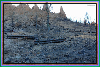
En la ida casi todo por sendero y carretera habremos visto fuera del sendero a la derecha bastantes lavas cordadas y los restos del incendio de agosto 2012.
Wanderroute Februar 2013
Schwierigkeit: leicht
Distanz: 10 km - Circular - 3 Stunden - teilweise - ausgeschildert, ohne Wasser
Startseite: auf Sicht der Boca Tauce - final - in derselben zu platzieren
Dies ist der Weg Nr. 18 des Nationalparks, beginnt neben dem Haus Juan Évora; einer der letzten
Pastoren waren innerhalb des Parks, die ersten 4 Kilometer sind bis zu Vergangenheit Roque Zeder, Herstellen einer Verbindung mit dem Pfad Nr. 35 (Mund Chavão) gekennzeichnet, aber wir nehmen Sie nicht diesen Weg, sondern dass wir hinter Los Roques, einen Pfad mit Punkten auf den Felsen, grüne markiert zum Ausgangspunkt zurück aber die zerklüfteten Gipfeln, wobei einige Inseln anzeigen auf klaren Tagenund Las Cañadas del Teide.
Auf dem Weg haben fast alle Weg und Trail, der Weg nach rechts genug Fadenziehender Lava und die Reste des Feuers im August 2012 gesehen.
Hiking route February 2013
Difficulty: easy
Distance: 10 km - circular - 3 hours - partly - signposted without provision of water
Home: on the viewpoint of Boca Tauce - final - in the same place
This is the path no. 18 of the National Park, begins next to the House of Juan Évora; one of the last
pastors who were inside the Park, the first 4 kilometers are marked up to past Roque of cedar, connecting with the path no. 35 (mouth Chavão) but we do not take this path, but that we got behind los roques, a path marked with points green on the rocks, to return to the starting point but the craggy peaks, taking some islands view on clear daysand las Cañadas del Teide.
On the way almost all road and trail have seen out the trail to the right enough stringy lava and the remains of the fire in August 2012.
 |
| casa juan evora |
 |
| primeros kilometros andados |
 |
| restos incedio |
 |
| lavas cordadas |
 |
| a la izquierda para bordear a las cumbres de los roques |
 |
| subiendo al roque del cedro |
.jpg) |
| mar de nubes |
 |
| narices del teide |


