Translate

miércoles, 18 de febrero de 2015

TENERIFE SENDEROS : EL JARAL -EL CHORO -ACOJEJA -EL JARAL

Ruta de Senderismo Febrero 2015
El Jaral - Guía Isora
Dificultad : Fácil
Distancia : 6 kilómetros- 3 horas - señalizado
Inicio : Caserío del Jaral - final - mismo lugar

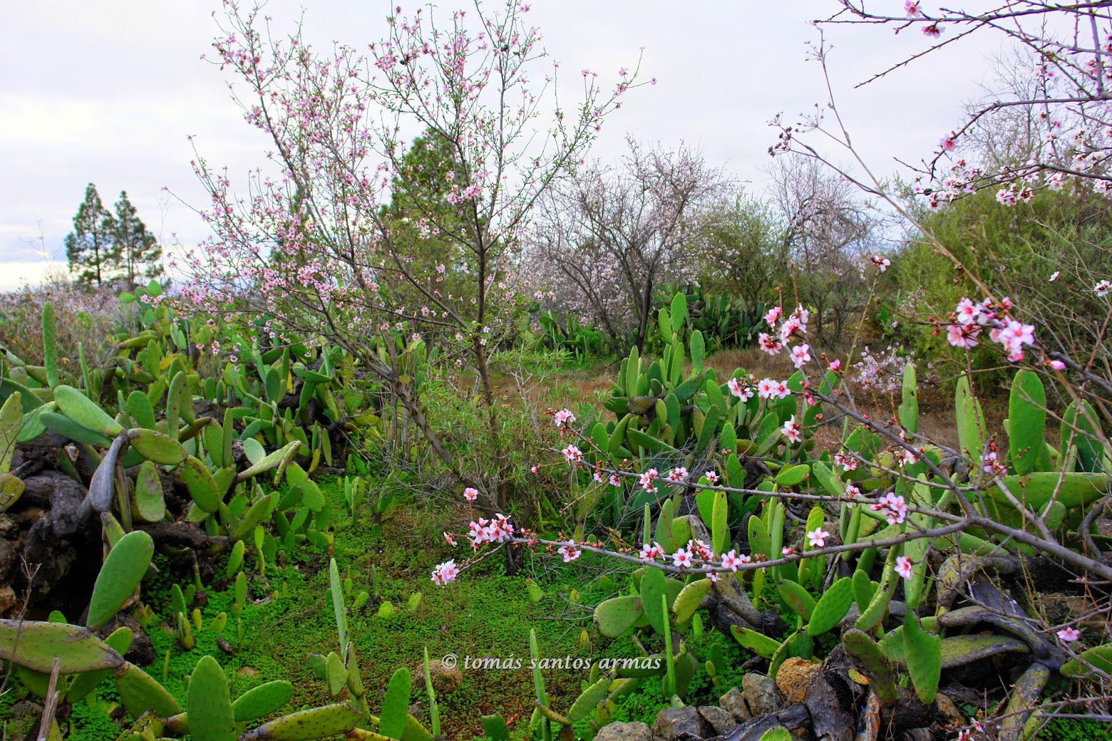
Esta ruta se inicia en el colegio del Jaral ,a la derecha vemos las señales ,por un ancho camino pasamos por unas casas en ruinas  con una era  dos hornos en buenas condiciones ,luego nos adentramos en un estrecho sendero que nos lleva hasta el cauce del Barranco del Pozo ,subimos a  la otra orilla en un suave ascenso ,para ir llegando al Choro una zona de fincas cultivadas  ,donde podremos enlazar y seguir hacia Las Fuentes ,Montaña Tejina o La Vera de Erques ,en este caso seguimos bajando en parte por la carretera y el sendero teniendo unas buenas vistas  de la costa de Guía Isora y el Jaral ,al pasar las últimas huertas veremos a la derecha una Era tallada en la roca y justo antes del cruce de caminos a Acojéja  veremos otro Horno ya solo nos que adentrarnos nuevamente en el Barranco del Pozo para en un suave descenso entre almendros en flor  ,llegar al cauce y comenzar a subir hasta el punto de partida el Jaral ,al llegar a las primeras casas veremos un Aljibe en muy buenas condiciones, ruta sencilla y muy bonita.

Wanderroute Februar 2015
El Jaral - Isora Guide
Schwierigkeit: leicht
Entfernung: 6 km - 3 Stunden-ausgeschildert
Startseite:: Weiler el Jaral - final - gleichen Ort

Diese Route beginnt am College von el Jaral, auf der rechten Seite sehen wir die Zeichen, ein breiter Weg gingen wir durch einige Häuser in Schutt und Asche mit einer Ära zwei Öfen in gutem Zustand, dann bewegen wir uns in einen schmalen Pfad, der führt zu dem Bett der Schlucht des Brunnens, wir müssen auf die andere Seite in eine leichte Steigung, Choro eine Fläche von kultivierten Betriebe erreichen gehen wo wir zu binden und weiter in Richtung Las Fuentes, Berg Tejina oder La Vera von Erques, in diesem Fall wir weiter unten Teil der Straße und Weg mit guter Aussicht auf die Küste von Isora Guide und el Jaral, übergeben die neuesten Obstgärten sehen auf der rechten Seite ein wurde geschnitzt in den Felsen und kurz vor der Kreuzung nach Acojeja einen anderen Ofen bereits nur uns Eintauchen in den Barranco del Pozo für wieder sehen werden ein sanfter Abstieg unter die Mandelbäume in voller Blüte, zur Startbahn bekommen und anfangen zu besteigen, der Ausgangspunkt der Jaral, sehen wir die ersten Häuser Haupthindernisse für eine Zisterne in sehr gutem Zustand, einfache und sehr schöne Route.

Hiking route February 2015
El Jaral - Isora Guide
Difficulty: easy
Distance: 6 km - 3 hours-signposted
Home:: Hamlet of el Jaral - final - same place

This route starts at the College of el Jaral, on the right we see the signs, a wide path we went through some houses in ruins with an era two ovens in good condition, then we move into a narrow path that leads to the bed of the ravine of the well, we got to the other side in an easy climb, to go reaching Choro a area of cultivated farms where we bind and continue towards Las Fuentes, mountain Tejina or La Vera of Erques, in this case we continue down in part the road and path with good views of the coast of Isora Guide and el Jaral, passing the latest orchards will see on the right a was carved in the rock and just before the crossroads to Acojeja will see another oven already only us delving again into the Barranco del Pozo for a gentle descent among the almond trees in bloom, get to the runway and begin to climb up to the point of departure the Jaral, arriving at the first houses we see a cistern in very good condition, simple and very nice route.


señales de inico
ancho sendero saliendo del jaral

una era y el jaral


casa en ruinas
horno
segundo horno


barranco del pozo


subiendo al otro lado

en el choro  el jaral y guia isora
costa de guia isora
el choro

era tallada y el jaral


el jaral

horno de acojeja


almendros en la baja a barranco del pozo


aljibe


en el jaral

viernes, 13 de febrero de 2015

TENERIFE SENDEROS : CAMINO DE MONTIEL - BARRANCO DE LAS CARRERAS

Ruta de Senderismo Febrero 2015
Vera de Erques - Guia Isora
Dificultad : Fácil
Distancia : 5 kilómetros--2 horas--ida y vuelta  -- señalizado
Inicio : Vera de Erques- final -- en el mismo lugar

Este sendero comienza en la carretera a Vera de Erques , unos trescientos metros antes de la iglesia veremos las señal a la izquierda , podemos seguir hasta Las Fuentes , El Jaral ,Guia Isora, Chirche o incluso Chio .Pero en este caso solo hacemos hasta el Barranco de Las Carreras cruzando el Barranco de Bicácaro ,veremos un horno en perfectas condiciones ,el caserío de Montiél con un aljibe ,lavaderos una casa una era y también la era del Tío Manuel ,en esta época están los almendros  los escobones y la hierba "mato risco" en plena floración dándole un colorido especial.
Sendero cómodo y vistoso.

Wanderroute Februar 2015
Erques Vera - Isora Guide
Schwierigkeit: leicht
Entfernung: 5 km - 2 Stunden - Runde und Runde – ausgeschildert
Home: Vera Erques - Finale - an der gleichen Stelle

Dieser Weg beginnt an der Straße zum Erques Vera, etwa dreihundert Meter vor die Kirche wird das Signal auf der linken Seite sehen, können zur Las Fuentes, El Jaral, Guia Isora, Chirche oder sogar Chio folgen.Aber in diesem Fall nur machen um den Barranco de Las Carreras überqueren der Schlucht von Bicácaro, wir werden sehen, ein Ofen in perfektem Zustand, den Weiler Montiel mit einer Zisterne, Waschen ein Haus eine Ära und auch Onkel Manuel-Ära, zu dieser Zeit sind die Mandeln der Mops und Gras Mato Risco in voller Blüte, gibt es eine spezielle bunte.
Komfortablen und attraktiven Pfad.

Hiking route February 2015
Erques Vera - Isora Guide
Difficulty: easy
Distance: 5 km - 2 hours - round and round - signposted
Home: Vera Erques - final - in the same place

This trail starts at the road to Erques Vera, about three hundred metres before the Church will see the signal on the left, can follow to Las Fuentes, El Jaral, Guia Isora, Chirche or even Chio.But in this case only will make to the Barranco de Las Carreras crossing the ravine of Bicácaro, we will see an oven in perfect conditions, the hamlet of Montiel with a cistern, wash a House an era and also Uncle Manuel era, at this time are the almond the mops and grass mato risco in full bloom, giving it a special colorful.
Comfortable and attractive path.


horno


casas de montiel


aljibe y lavaderos

montaña de tejina

almendros

la gomera

barranco las carreras


mato risco  y la gomera


domingo, 8 de febrero de 2015

TENERIFE SENDEROS : ALMENDROS LAS MESAS - VILAFLOR

Ruta de Senderismo febrero 2015
Vilaflor
Dificultad : Fácil
Distancia : 5 kilómetros  - 3 horas - ruta  sin señalizar
Inicio : justo en la entrada del área recreativa Cho Pancho --final -- en el mismo lugar

Este sendero carece de señales informativas ,pero vale la pena, ya que improvisaremos caminando entre los muchos almendros de la zona .Para llegar al punto de inicio tomamos la carretera tf 563 ( San Miguel - Vilaflor) después de unos 4 kilómetros veremos la entrada al área recreativa  "Cho Pancho" justo ahí podemos empezar por la orilla del Barranco de Las Mesas y paralelo a la carretera veremos una casa en ruinas con una era y algunos hornos entre los almendros ,muchos de estos blancos ,es recomendable llevar pantalón de manga baja por la maleza que encontraremos por los diferentes senderos , de cabreros y cazadores que seguiremos ,teniendo precaución con las abejas y respetando las colmenas que encontraremos ,con cuidado es un sendero muy ameno y vistoso.

Wanderroute Februar 2015
Vilaflor
Schwierigkeit: leicht
Entfernung: 5 km - 3 Stunden - ohne Signalisierung
Home: am Eingang des Erholungsgebietes Cho Pancho - endgültig - im selben Ort

Dieser Pfad hat keine Anzeichen, aber lohnt sich, da wir Improvisaremos Wandern zwischen den vielen Mandelbäumen im Bereich.Erreichen die ab Punkt nehmen die Tf 563 (San-Miguel - Vilaflor) nach ca. 4 km den Eingang zum Erholungsgebiet Cho Pancho rechts sehen werden es können wir entlang der Schlucht der Tabellen beginnen und parallel zur Straße, ein Haus in Schutt und Asche mit einer Ära und einige Öfen unter den Mandelbäumen zu sehen, viele dieser Ziele Es ist ratsam, die Hose niedrig Manga von Unkraut zu tragen, die wir finden verschiedene Wege, Hirten und Jäger, dem wir folgen wird, kümmert sich mit den Bienen und respektieren die Bienenstöcke, die wir finden, mit Sorgfalt ist eine sehr unterhaltsame und bunte Spur.

Hiking route February 2015
Vilaflor
Difficulty: easy
Distance: 5 km - 3 hours - without signalling
Home: at the entrance of the recreational area Cho Pancho - final - in the same place

This path has no signs, but is worthwhile, since we improvisaremos walking among the many almond trees in the area.To reach the starting point take the tf 563 (San Miguel - Vilaflor) after about 4 kilometers will see the entrance to the recreation area Cho Pancho right there we can begin along the ravine of the tables and parallel to the road to see a house in ruins with an era and some ovens among the almond trees, many of these targets It is advisable to wear pants low manga by weeds that we will find different trails, herdsmen and hunters we will follow, taking care with the bees and respecting the hives that we find, with care is a very entertaining and colorful trail.

barranco de las mesas


horno de secado


horno


horno de cocción