Translate

jueves, 14 de julio de 2016

TENERIFE SENDEROS : ERJOS - LAS CHARCAS - MORRO VERDE - ERJOS

Ruta de Senderismo Julio 2016
Erjos
Dificultad : Moderado
Distancia : 12 Kilómetros - 4 horas - circular - señalizada
Inicio : Plaza de Erjos - final - En el mismo lugar
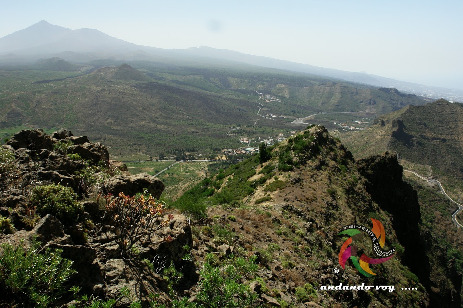
Este sendero lo comenzamos justo frente a la Iglesia de Erjos , seguimos las señales Punta Teno ,caminaremos por una pista sendero algo más de un kilómetro y medio hasta pasar junto a las charcas de Erjos y ahí comienza un ligero ascenso por un camino entre zarzales hasta llegar a una pista asfaltada ,junto a esta veremos las señales seguimos a Punta Teno ,cruzamos el asfalto y seguimos por otra pista de tierra ,en un ligero descenso entre pinos tras recorrer casi dos kilómetros con vistas al Teide y Santiago del Teide al terminar la pista tendremos un corto pero intenso ascenso por un camino estrecho entre piedras y estaremos en unos novecientos metros en la Degollada El Terrero de La Mesa ,aquí tendremos unas grandes vistas en días claros de Masca ,La Gomera y La Palma y a nuestra espalda del Teide y todo el Valle de Santiago ,ahora subimos por un corto sendero hacía la izquierda al alto de Morro Verde , no tendremos que escalar ni descolgarnos por las rocas iremos caminando ,pero esta zona no es apta para personas con vértigo y que no tengan paso firme y por supuesto no realizar este pequeño tramo en días de lluvia o excesivo viento. Aquí tendremos una buena panorámica de Masca , regresamos al sendero principal y ahora tendremos algo más de un kilómetro por una cornisa sobre el Valle de Masca ,cuando pasemos los captadores de niebla que veremos con sus señales llegaremos a un cruce aquí tomamos a la derecha por la pista de Las Barreras ( sin señales de ningún tipo ) a la derecha continuando siempre hacia la izquierda y en algo más de dos kilómetros esta pista se cruza con la primera asfaltada entre pinos ,ahora solo tenemos que seguir a la izquierda y desandar parte del sendero que habíamos hecho hasta llegar al punto de partida.


Route des Wanderns Juli 2016
Erjos
Schwierigkeit: mäßig
Entfernung: 12 km - 4 Stunden - Kreis - ausgeschildert
Home: Plaza Erjos-Finish-in der gleichen Stelle
Dieser Weg begann es direkt vor der Kirche Erjos, folgen wir Signale Punta Teno, Spaziergang entlang eines Tracks trail etwas mehr als einen Kilometer und eine halbe, bis Sie die Teiche Erjos vorbei und es beginnt einen leichte Aufstieg entlang eines Pfades zwischen Zarzales bis Sie erreichen eine asphaltierte Strasse, daneben sehen Sie die Zeichen weiterhin Punta Teno , überquerte den Asphalt und weiter durch eine andere Spur des Landes, in einem leichten Abstieg zwischen Kiefer nach gehen fast zwei Kilometer mit Blick auf den Teide und Santiago des Teide bis zum Ende verfolgen haben einen kurzen, aber intensiven Aufstieg durch eine Straße schmal zwischen Steinen und wird in die 1900 s-Meter in den Rio Grande Halsabschneider Terrero der Tabelle, hier haben einige große Ansichten in Tagen frei von Masca , La Gomera und La Palma und blieb hinter den Teide und das Tal von Santiago, jetzt gings auf einen kurzen Wanderweg auf den Gipfel des Morro Grün, müssen nicht klettern oder heben uns die Felsen, die wir zu Fuß werden wird, aber dieser Bereich ist nicht geeignet für Menschen mit Schwindel und haben keine festen Schritt und sicherlich nicht machen diese kleine Strecke bis Tage Regen oder starkem Wind. Hier wird haben wir einen schönen Blick auf Masca, wir kehrten in den Hauptweg und jetzt wir haben mehr als einen Kilometer von einem Gesims über das Tal von Munch, wenn wir an die Sensoren der Nebel, die wir, mit ihren Signalen sehen kommen an eine Kreuzung hier schaltet sich direkt entlang der Strecke der Barrieren (ohne Anzeichen jeglicher Art) auf der rechten Seite weiter, immer auf der linken Seite und in etwas mehr als zwei Kilometer dieser Strecke schneidet das erste gepflastert, zwischen Pinien, jetzt nur noch nach links folgen und Teil der Strecke, die Sie gemacht hatte, bis zu dem Punkt von Split zurückverfolgen.


Hiking route July 2016
Erjos
Difficulty: moderate
Distance: 12 km-4 hours-circular-signposted
Home:: Erjos square - final - in the same place
This trail it started just facing the Church of Erjos, continue them signals Punta Teno, walk by a track trail something more than one kilometer and half until pass next to them ponds of Erjos and there begins a light rise by a road between zarzales until get to a track paved, next to this will see them signals continue to Punta Teno We crossed the asphalt and continue for another dirt track, in a slight decline among pines after traveling almost two kilometers with views of Mount Teide and Santiago del Teide at the end of the track will have a short but intense climb by a narrow road between stone and will be in about nine hundred meters in the cutthroat El Terrero's table, here we will have great views on clear days MASCA , La Gomera and La Palma and behind of the Teide and the Valley of Santiago, now we went up a short trail was left to the top of Morro Green, will not have to climb or lift us up the rocks we will be walking, but this area is not suitable for people with vertigo and having no firm step and certainly not make this small stretch to days of rain or excessive wind. Here we will have a nice view of Masca, we returned to the main path and now we will have more than one kilometre by a cornice above the Valley of Munch, when we pass the sensors of fog that we see with their signals arrive at a crossroads here turn right along the track of the barriers (without signs of any kind) to the right continuing always to the left and into something more than two kilometers this track intersects the first paved between pines, now only have that follow to the left and retrace part of the trail that had made up to get to the point of split.


iglesia de erjos 


primeras señales
charcas de erjos 


desde la pista entre pinos 

santiago del teide

vistas desde morro verde 
degollada terrero de la mesa 


santiago del teide 

el teide

volvemos al camino  principal
por la cornisa sobre masca

martes, 28 de junio de 2016

TENERIFE SENDEROS : RUTA ARENAS NEGRAS

Ruta de Senderismo Junio 2016
Parque Nacional del Teide
Dificultad : Fácil
Distancia : 8 kilómetros - 3 horas - señalizado
Inicio : Frente al centro de visitantes del Portillo - final - en el mismo lugar


Este es el senderos nº 2 de la red del Parque Nacional ,a unos trescientos metros del inicio veremos el primer cruce , que es donde realmente comienza el sendero ,tenemos varias indicaciones nº 2-nº20-nº37-nº8 esos son los senderos que podemos conectar ,para realizar el circular nos olvidaremos de los cruces y seguiremos siempre a la derecha  .Al principio iremos en una ligera subida dejando al Teide a nuestra espalda y el Alto de Guamazo a la izquierda  y al fondo La Fortaleza  e iremos subiendo por las faldas de Montaña del Cerrillar ,ahora empezamos a ver el Observatorio de Izaña  , ignoramos el cruce a la izquierda , tenemos una ligera subida por una especie de cañada ,en unos cientos de metros volveremos a ver el Teide de frente ,tendremos a Montaña Maja a la izquierda , comenzamos un tramo llano y luego una bajada ,siempre iremos entre grandes retamas ,codeso y rosalillos de cumbre en esta época en floración .Ahora ya vemos Arenas Negras ,a la izquierda nos queda el Llano de Maja con unas alambradas , seguimos el ligero descenso hasta llegar a un pequeño cañón  conocido como Fuente de Las Arenas Negras , en este sitio podremos ver una buena cantidad de Tajinastes azules o Picantes ( Echium auberianum ) muy vistosos ,ahora tenemos unas vistas del circo de Las Cañadas ,Montaña Mostaza y el Teide detrás ,estamos en Montaña Arenas Negras , iniciamos un corto pero intenso descenso que nos lleva hasta el sendero nº4 Siete Cañadas  ,ya solo tenemos que seguir a la derecha y en poco más de un kilómetro estaremos en el punto de partida.

Entfernung: 8 km - 3 Stunden - gekennzeichnet
Nach Hause: Gegenüber der Visitor Center von Portillo - Finale - im selben Ort

Dies ist die Wanderwege Nr. 2 des Netzwerks des Nationalparks, etwa dreihundert Meter von der Wohnung zur erste Kreuzung, die wo es wirklich beginnt des Weges sehen, wir haben mehrere Hinweise Nr. 2 - n ° 20 - n ° 37 - Nr. 8 sind die Wege, die wir herstellen können, stellen Sie die kreisförmige Kreuzungen, die wir vergessen und wird immer, nach rechts weiter. Am Anfang wir auf einer kleinen Anhöhe verlassen den Teide hinter uns und der Alto de Guamazo nach links und im Hintergrund die Festung und Klettern an den Hängen des Berges Cerrillar, wir beginnen jetzt zu sehen, Izana Sternwarte, ignorieren die Straße auf der linken Seite, haben wir einen leichten Anstieg durch eine Art von Kanada, in ein paar hundert Meter wird der Teide von vorne zu sehen Wir müssen links Berg Maja, begann eine einfache Strecke und dann eine unten, gehen immer zwischen den großen Besen, Codeso und Rosalillos des Gipfels zu dieser Zeit in Blüte. Jetzt sehe ich Arenas Negras, links der Llano de Maja mit Stacheldraht ist uns, wir folgen den leichten Rückgang bis Sie einen kleinen Canyon bekannt erreichen, wie die Quelle von Arenas Negras, auf dieser Website eine Menge von blauen Tajinastes oder würzig (Echium Auberianum) sehr auffällige sehen werden, nun blicken Las Cañadas, Berg-Senf und den Teide hinter Circus Wir befinden uns in Montana Arenas Negras, beginnen wir einen kurzen, aber intensiven Abstieg, der uns auf den Weg Nr. 4 führt sieben Täler schon du musst nur auf der rechten Seite folgen und in wenig mehr als einem Kilometer wird der Ausgangspunkt sein.

Hiking route June 2016
Teide National Park
Difficulty: easy
Distance: 8 km - 3 hours - marked
Home: Opposite the visitor center of the Portillo - final - in the same place

This is the trails No. 2 of the network of the National Park, about three hundred meters from the home will see the first intersection, which is where it really begins the trail, we have several indications no. 2-n ° 20 - n ° 37 - No. 8 these are the paths that we can connect, make the circular intersections we forget and will always continue to the right. At the beginning we will be on a slight rise leaving the Teide behind us and the Alto de Guamazo left and in the background the fortress and go climbing up the slopes of the Cerrillar mountain, we now begin to see Izana Observatory, ignore the road on the left, we have a slight rise by a species of canada, in a few hundred metres will see the Teide from front We'll have mountain Maja left, started a plain stretch and then a down, always go between large brooms, codeso and rosalillos of Summit at this time in flowering. Now I see Arenas Negras, left the Llano de Maja with barbed wire is us, we follow the slight decline until you reach a small Canyon known as the source of the Arenas Negras, in this site will see a lot of blue Tajinastes or spicy (Echium auberianum) very showy, now have views of Las Cañadas, mountain mustard and the Teide behind circus We are in Montana Arenas Negras, we begin a short but intense descent that leads us to the path n ° 4 seven Glens, already you just have to follow on the right and in little more than one kilometre will be the starting point.


primer cruce y señales

dejando atras el teide

mar de nubes

observatorio de izaña


ahora de frete al teide

llano de maja


tajinaste azul y el teide


grupo de tajinastes  pequeño cañon fuente de arenas negras

arenas negras desde abajo

cruce con siete cañadas


domingo, 26 de junio de 2016

TENERIFE SENDEROS : MIRADOR DE BARRACAN - TENO ALTO - MIRADOR DE BARRACAN

Ruta de Senderismo Junio 2016
Parque Rural de Teno
Dificultad : Fácil
Distancia: 8 kilómetros  - 3  horas - señalizado.
Inicio : Mirador de Barracán - final - en el mismo lugar.


Este sendero lo iniciamos en el Mirador ,pasado Masca y Los Carrizales por la carretera tf 436 lo veremos  a la izquierda  ,justo antes de comenzar a ver Las Portelas ,se inicia en un ligero ascenso ,tras el primer kilómetro estaremos en  el alto de Barracán ,con unas grandes vistas a ambos lados El Palmar ,Las Lagunetas ,los caseríos de Los Carrizales , Masca , del Teide , La Gomera y La Palma en días claros ,ahora comienza un ligero descenso hasta llegar a un pequeño bosque de laurisilva que atravesaremos  ,después solo nos quedará  poco más de un kilómetro para llegar a Teno Alto ,aquí tendremos varias opciones con senderos señalizados ,seguir a Buenavista o al Palmar ,además de poder continuar por este último hasta Erjos,en nuestro caso volveremos al punto de partida ,claro está  después  de degustar un plato de carne de cabra y queso blanco en los comercios del pueblo.

Wanderroute Juni 2016
Teno-Naturpark
Schwierigkeit: leicht
Entfernung: 8 km - 3 Stunden - gekennzeichnet
Startseite:: Aussichtspunkt Barracán - Finale - an der gleichen Stelle
Dieser Weg begann es in el Mirador, Masca und den Röhrichten unterzogen die Carretera Tf 436 sehen sie auf der linken Seite, kurz bevor Sie anfangen, die Portelas zu sehen, es beginnt auf einer kleinen Anhöhe, nach die erste Kilometer an der Spitze des Barracán, mit herrlichem Blick auf beiden Seiten, El Palmar, Las Lagunetas, die Weiler Los Carrizales werden , An klaren Tagen, den Teide, La Gomera und La Palma munch, jetzt beginnt eine leichte Abfahrt, bis Sie einen kleinen Wald Laurisilva überqueren, erreichen, dann wir nur wenig werden mehr als einen Kilometer nach Teno Alto, hier wir haben mehrere Möglichkeiten mit markierten Wanderwegen, Buenavista oder el Palmar, zusätzlich zu halten können weiterhin durch Letzteres bis Erjos , in unserem Fall wir zum Ausgangspunkt kehren, klar ist nach Geschmack ein Gericht aus Fleisch Ziege und weißen Käse in den Geschäften im Dorf.

Hiking route June 2016
Teno Rural Park
Difficulty: easy
Distance: 8 km - 3 hours - marked
Home:: Viewpoint Barracán - final - in the same place
This path started it in el Mirador, Masca and the reedbeds undergone the carretera tf 436 will see it on the left, just before you begin to see the Portelas, it starts on a slight rise, after the first kilometer will be at the top of Barracán, with great views of both sides, El Palmar, Las Lagunetas, the hamlets of Los Carrizales , Munch on clear days, Mount Teide, La Gomera and La Palma, now begins a slight descent until you reach a small forest of laurisilva cross, then only we will be little more than one kilometer to Teno Alto, here we have several options with marked trails, keep Buenavista or el Palmar, in addition to be able to continue by the latter until Erjos , in our case we will return to the starting point, clear is after taste a dish of meat goat and white cheese in the shops in the village.


inicio barranco los carrizales


las portelas y el teide


entrada al bosque
bosque de laurisilva

alto de barracan


ermita de teno alto


jueves, 23 de junio de 2016

TENERIFE SENDEROS : VOLCÁN DE FASNIA

Ruta de Senderismo Junio 2016
Parque Nacional del Teide
Dificultad : Fácil
Distancia : 9 kilómetros - 3 horas - señalizado
Inicio : Junto a la entrada del Observatorio de Izaña - final - en el mismo lugar

Este es el senderos nº 20  de la red del Parque Nacional ,es circular caminaremos entre grandes retamas y codesos .Tendremos siempre unas buenas vistas del Teide y en días claros de Gran Canaria e incluso La Palma ,a nuestra espalda iremos dejando el Observatorio de Izaña uno de los más importantes de Europa ,los primeros kilómetros son por terreno llano para luego ir descendiendo en dirección al Volcan de Fasnia que destaca ,  su color negro con el contraste de los colores de la Primavera ,junto al sendero veremos algunos tajinastes azules o picantes (Echium auberianum ) que son bastante escasos en todo el Parque Nacional , al llegar a los pies del Volcán de Fasnia si tendremos unos cuantos  grupos de ejemplares ,ya solo nos falta poco más de un kilómetro para llegar al punto de partida  

Wanderroute Juni 2016
Teide-Nationalpark
Schwierigkeit: leicht
Entfernung: 9 km - 3 Stunden - gekennzeichnet
Nach Hause: Zusammen am Eingang von der Sternwarte von Izaña - Finale - im selben Ort


Dies ist die Wanderwege Nr. 20 des Netzwerks des Nationalparks, ist eine Rundwanderung zwischen großen Besen und Codesos. Wir haben immer gute Aussicht auf den Teide und an klaren Tagen von Gran Canaria und La Palma, hinter uns, die wir, Izana Observatorium eines der wichtigsten in Europa verlassen wird, die ersten Kilometer sind flaches Land, dann gehen Sie in Richtung der Fasnia-Vulkan, der herausragend, ihre schwarze Farbe mit dem Kontrast zwischen den Farben des Frühlings entlang des Weges sehen einige blau oder würzigen Tajinastes (Echium Auberianum) sind in allen Nationalpark, am Fuße des Volcán de Fasnia ankommen, haben wir ein paar Gruppen von Exemplaren sehr selten, nur wir brauchen etwas mehr als einem Kilometer um den Ausgangspunkt zu erreichen

Hiking route June 2016
Teide National Park
Difficulty: easy
Distance: 9 km - 3 hours - marked
Home: Together at the entrance of the Observatory of Izaña - final - in the same place


This is the trails No. 20 of the network of the National Park, is a circular walk between large broom and codesos. We will always have good views of the Teide and on clear days from Gran Canaria and La Palma, behind us we will be leaving Izana Observatory one of the most important in Europe, the first kilometres are flat land to then go down towards the Fasnia volcano that stands out, its black colour with the contrast of the colors of spring along the trail will see some blue or spicy tajinastes (Echium auberianum) are very rare in all national park, arriving at the foot of the Volcán de Fasnia if we will have a few groups of specimens, only we need little more than one kilometer to reach the starting point.


inicio del sendero


volcán de fasnia

observatorio de izaña


tajinastes azules


volcán de fasnia