Erjos
Dificultad : fácil
Distancia : 4'5 kilómetros--circular --2 horas--señalizado
Inicio : Ermita de Erjos --final --mismo lugar
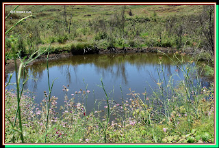
Pequeño sendero para visitar Las Charcas de Erjos,las cuales se formaron en los años 70 ,con la extracción de tierra para llevarla a la zona de cultivos del sur de la isla ,quedando unos grandes hoyos que gracias a la impermeabilidad del terreno mantienen un nivel de agua bastante aceptable durante todo el año ,siendo una zona con gran variedad de fauna y algunas aves migratorias.
Wanderroute Juni 2013
Erjos
Schwierigkeit: leicht
Entfernung: 4'5 km - Rundschreiben - 2 Stunden - ausgeschildert
Startseite: Einsiedelei von Erjos - final - gleichen Ort
Schmalen Pfad, Las Erjos Teiche, zu besuchen, die gebildet wurden, in den 1970er Jahren, mit der Gewinnung von Erde, bringen es auf den Bereich der Kulturen im Süden der Insel, verlassen ein paar große Löcher, die durch die Undurchlässigkeit des Feldes eine durchaus akzeptabel Wasserstand ganzjährig gepflegt wird ein Bereich mit Vielzahl von Wildtieren und Zugvögel.
Hiking route June 2013
Erjos
Difficulty: easy
Distance: 4'5 km - circular - 2 hours - signposted
Home: Hermitage of Erjos - final - same place
Small path to visit Las Erjos ponds, which were formed in the 1970s, with the extraction of Earth to bring it to the area of crops in the South of the island, leaving a few large holes that due to the impermeability of the field maintained a quite acceptable water level throughout the year, being an area with wide variety of wildlife and migratory birds.
 |
| ermita de erjos |
 |
| ruyman y chispita |
 |
| ruyman eladio y chispita |
 |
| charcas de erjos |
 |
| regresando |


No hay comentarios:
Publicar un comentario